Alien's and The Paranormal


Home

Area 51
Roswell 1947
Conspiracies - JFK
Conspiracies - Scientific Evidence of E.T's
Project Blue Book
S-4 Secret Facility
S-4 Secret Facility

s4render.jpg

The Papoose Lake Primer


Why should anyone care about Papoose Lake? Aliens, of course!! According to some, it's where our beloved government has stashed all the extraterrestrial debris that has rained down upon our planet in the last 50 years or so, the result of intergalactic student drivers. There are even some folks who'll take the story further and suggest that ET and his buddies themselves have taken up residence there (talk about a lousy neighborhood!). Are these people nuts?! Are they just mislead? Or are they right? (or some very strange combination of all three!)

What I'm going to do is lay out all the stories I'm aware of regarding Papoose Lake, covering both sides of the issue. As you'll see, there are points to be made for either case, some points stronger than others. Whichever side you come down on, you need to be aware of and explain these opposing points.

  • The Pros and Cons of a saucer facility at Papoose Lake. A very schizophrenic look at both sides of the argument. Make up your own minds! Not exhaustive, but a start.

Good Reasons Why There is Something Odd at Papoose Lake


Bob Lazar's Story

Face it, Bob Lazar is the main reason the public is aware of Goom Lake (and to a lesser extent, Papoose Lake) today. Whether his tale is true or not, when he went public in 1989, he ignited a firestorm of interest in Area 51 which burns to this day. As most of you already know, Lazar described how he was flown from Las Vegas to Groom Lake, then taken on a bus with blacked out side windows to a facility he determined was known as S-4.

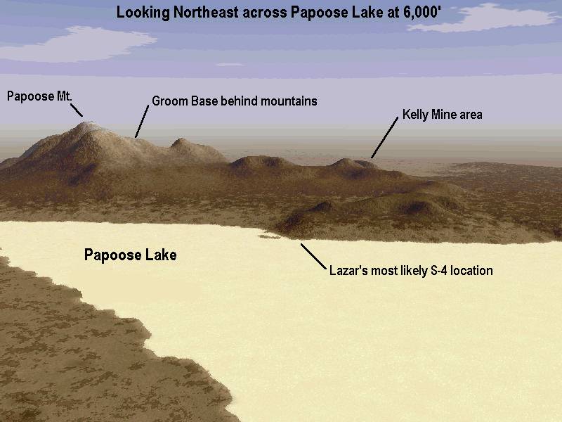
Now when Lazar arrived at S-4, he wasn't warmly greeted with a "Howdy Bob, this here underground facility is under the Papoose Mountains and that there dry lake over there is Papoose Lake." He was simply driven in the bus for about 30 minutes and there he was. At some later date, he, Gene Huff, and John Lear got together and worked out where it must have been, based upon various clues Lazar noted during the trip. From what they deduced, S-4 would have to be on the east side of Papoose Lake, where the Papoose Mountains slope down to meet it. Since the short flight test of the one disc he witnessed took place on the dry lake bed, the edge of the dry lake must have been very close to the installation.

Lazar described the facility to Timothy Good as being built into the base of the Papoose Range, with 9 hangar doors sloped at about a 60 degree angle. He said the doors had a sand-like texture coating to them, and Gene Huff later said the doors were rollup type doors. There were 9 of the hangar bays in all.

Per Lazar, the disc he described as the "Sport Model" had an approximate diameter of 52'. Allowing for adequate work clearance, it's reasonable to assume a hangar bay would be at least 70' wide. So for 9 bays, the overall length of the facility would have to be at least 630', maybe more.

On the "Billy Goodman Happening" radio show, Lazar described the dirt road the bus took to S-4 as a "good dirt road." When a caller asked him if the facility was underground, he replied, "No, it's not underground; it's just butt up against the side of a little mountain, a little hill kind of, but it's kind of inside the mountain."

Questions and answers on the subject of S-4. Digging around for details that might have been overlooked in the past. A few interesting items (at least to me) did turn up out of the exchange. The following are excerpts of three exchanges that have been combined in to one Q&A session. Deleted information not pertaining to the S-4 topic. As you read it, remember that what you are reading are Gene Huff's replies to the questions, as he remembers what Lazar told him. In that sense, it is second hand and errors or other distortions may be introduced:

Question:

Did the bus drop off Lazar in front of the hangars, do a U turn and return to Groom, or did the bus remain on site?

Answer:

-No, there was an area enclosed with a chain link fence on the non-hangar side of the installation and they entered through that side. Apparently the installation is/was on a corner of one of the jags in the mountain. The only night he entered through the hangar side was the first night they showed him the sport model which is the night he walked right by it and rubbed his hand on it. He and Mariani went inside after they were dropped off so he never knew the time schedule or whereabouts of the bus after that.-

Question:

Do I understand you correctly that the facility passed completely through a ridge, with the hangars on one side and the "entrance" on the other?

Answer:

-"Through a ridge" might be somewhat misleading. I don't think Bob was enough places in the facility to state that it passed through an entire ridge. However, yes, it did pass through the corner of a jag/ridge in the mountain. The hangars were on one side of the corner and the pedestrian entrances were around the corner from that.

Question:

What was the size of the chain linked area and could it have been visible from certain directions?

Answer:

-I don't know and I've never heard Bob guestimate that. In fact, you're the first one who's ever been that interested. This chain link fence was big enough to have gates on it and the gates were opened to allow the bus in.-

Question:

Since you said one night he entered through the hangar side after Lazar was dropped off, I assumed the bus pulled up in front of the hangars instead of he and Mariani walking around the hill.

Answer:

-I should have clarified that, as that must also be the reason you thought Bob should have been more aware of a synthetic tarmac if there was one. That night the bus dropped them off at the regular spot and, when Bob started walking toward the door, Mariani said, "We need to go this way tonight, Bob". Then they walked around the corner, more or less hugging the building and entered through the hangar side. If I remember correctly, there was also another gate they had to go through to get to the hangars. I think this gate was simply the side of the chain link enclosed area which the bus entered.-

So in summary, what have we been told by Lazar and company? That S-4 is on the east side of a dry lake (most probably Papoose Lake), about a 30 minute bus ride from Groom via a good dirt road. The facility seems to be either built into a ridge spine, or disguised as a ridge spine, with portions of the facility being on either side. The hangar side must be at least 600' long, perhaps longer. There is a chain link fence with a gate surrounding the personnel entrance, but it's possible to walk around to the other side of the ridge to access the hangar area directly.

"Alfred's" Story

Alfred is the pseudonym of a gentleman I interviewed in April of 1994 at the suggestion of Glenn Campbell. Parts of his story have been reported by Campbell in his Desert Rat, issue 23. What follows is a very brief summary of what he had to say.

Alfred was a civilian photographer who worked at the Test Site from around 1960 to 1964, under the supervision of one Otto Krause, who in turn worked for Lawrence Livermore Laboratory. His photo group was allowed liberal access to various areas of the Test Site, as well as use of a generally restricted item, binoculars. He told me that on several occasions he was up on Rainier Mesa, with a clear view toward the Groom area. During some of these times he said he sighted several glowing discs, usually emanating from an area south of Groom, Papoose Lake. He said he saw them both during the day but mostly at night when he had to work late. During the day they appeared as grayish aluminum, and at night as glowing discs. They apparently had tremendous manuevering capabilities as he stated, "They could be out of sight going straight up in about 3 or 4 seconds. I mean totally out of sight, where with binoculars you couldn't see them."

Alfred had an interest in UFOs since his childhood, when he spotted some (along with the rest of his Farmington, New Mexico town) during a major UFO flap in 1949. During a card game with his photo group one night, he asked Otto about what he had seen. Otto then related how the US had recovered a vehicle from the Roswell crash (remember this was in the very early 1960's before anyone had heard of Roswell), and also one from Aztec, New Mexico. Otto said the materials were eventually taken to "the Test Site", (implying Area 51) and the US was working to unlock the secrets of how they worked. Otto said they functioned on some sort of magnetic principle.

Otto said that a 3 man version had been constructed and had been taken to the west Texas area for testing. Apparently things did not work out well with it and due to its magnetic effects, power was knocked out in several west Texas towns (It sounds like the Loveland, Texas incident).

Taken by itself, it could just be another tall tale of the Test Site. However Stanton Friedman got interested in the story and did a little research. He found that Otto had died in 1990, but was able to get in touch with Otto's son. His son recalled his dad telling similar stories to him, but had simply dismissed them as tall tales. Friedman also found a few of Alfred's co-workers. They recalled the night of the card session and generally corroborated Alfred's account of what Otto had to say.

Hesemann's Tape

In 1995, German filmaker Michael Hesemann produced a videotape called "Secrets of the Black World'. It is a look at Area 51, as well as other conspiracy topics (underground bases, etc.) in the southwest. It contains interviews with a large number of people, including Bob Lazar, George Knapp, John Lear, Norio Haiakawa, Gary Schultz, Sean Morton, and others. One of the interviews is with someone Hesemann identifies as Derek Hennesy, who claims to be a former guard at S-4.

The interview takes place somewhere in the desert because, as Hennesy says, " ..he's on the run...kinda scared". Hennesy goes on to describe a large underground facility consisting of 4 levels, of which the hangars are on level 2. He didn't know what was on level 3 or 4 as his responsibility was only on level 2. He said he did see alien bodies in vertical containers at one location on his level. For the benefit of the camera, he sketches a crude map of level 2. Supposedly he and his story were "checked out" by Wendell Stevens".

The A-12 Mechanic

This story is from a worker who was a repair mechanic for SR-71 or A-12 aircraft. Around 1969, he found himself doing duty at Groom Lake. He considered it pretty undesirable, as he found there was nothing to do and they were stuck out in nowhere. As he put it, "There was nothing to do but drink." He said there were a few places that the staff at Groom weren't allowed to go, one of which was "over the hill", meaning Papoose. He had heard rumors, and he and his buddies made some attempts to push the limits of where they were allowed to roam, but they never saw anything out of the ordinary. The point of this story is that even as far back as 1969, the Papoose Lake area was strictly off limits to even the highly cleared Groom personnel.

A Former Groom Worker

This is related by a person I have met and have a feel for his credibility. To me he seems quite believable, and I can think of no reason to question his story.

He worked at Groom for a limited time in the early 1980's. While socializing with the other workers (i.e., drinking at the bar), he heard stories of a big project going on at Papoose Lake, at a facility called, as he was told, "S-4". A great number of people were involved, but he did not know on what. Beyond that, he never saw or heard anything else unusual during his stay at Groom.

Other Reports

There are quite a number of odd and strange reports of happenings in the Groom/Papoose area. Rather than go through the rather large a list, I'd simply suggest any of George Knapp's videos, or perhaps Timothy Good's "Alien Contact" book. The latter part of the book contains quite a few sightings, of varying quality.

Sightings in the Area

While sightings accounts are not quite as substantial as eyewitness, on-site descriptions of what might be going on at Papoose, they should be considered. Probably the vast majority of sightings made near Area 51 may be dismissed as the misinterpretation of aircraft testing and wargames. Then there are the just plain stupid ones, like the mis-dentification of the landing lights of the incoming Janet flights to Groom as "Old Faithful". Still, after all the even remotely questionable sightings are discarded, there remain a few by credible observers.

As an example, one of the sightings I have some knowledge of was made by Mark Farmer. Mark Farmer has a high knowledge of aircraft and various forms of cutting edge technology. On a visit to the area, in January of 1994, on a Wednesday night, he was in the desert off Hwy. 375, west of Hancock Summit. At 10:14 PM, he observed a glowing light rise in the southwest from behind the mountains. The bearing of the light was not that of the Groom base, but rather more to the south. Although he had no solid idea of the distance, the bearing would put it in line with the Papoose area.

As he watched it for the next hour and 45 minutes, it made sharp, instantaneous horizontal movements, near-instantaneous turns, then it would slowly wobble for minutes at a time, then become rock solid. Although his photographs show little more then an interesting light streak, he reports that through his Celestron telescope the object appeared as an oblate spheroid (a squashed ball). The upper most portion appeared crimson, and the bottom most portion was green. The area in between was a golden color. He said it appeared the colors were the result of some sort of discharge, and than the colors obscured whatever might be below.

Despite Mark's considerable aerospace knowledge, he freely admits he has no idea what the hell it was he saw. It certainly behaved like no conventional aircraft he had ever come across.

One Last Bit of Possibly Related Weirdness:

This report is also from the illustrious Mark Farmer. It is one of those "friend of a friend" reports, so its reliability is difficult to assess, but it is an intriguing bit of weirdness.

The story comes from an Air Force communications specialist stationed in Alaska, whose job it was to monitor radio traffic, both ours and the Soviets, back when there was a Soviet Union. This individual had standing orders to relay any intercepted radio traffic dealing with UFOs (either Soviet or ours) to a certain department in the National Security Agency. This person never had occasion to implement those orders ,as no UFO radio traffic was ever picked up, but those were the orders.

The Department in the NSA? The routing header was "S4B, Doughboy".

Good Reasons Why This S-4 Business is All Lies


Most of the evidence of the existence of a secret facility at Papoose Lake is anecdotal. Tales told by people, which we have no way of confirming. But there are other things that can be considered, things that are public and can be verified. Common sense things like if "A" exists, then so must "B" and "C". If a facility exists, even if highly secret, there must be some sort of legal property ownership. Also there are certain bureaucratic patterns that can be looked for, and their presence (or absence) can be revealing. Finally, to paraphrase Jaques Vallee, sombody has to take out the trash.

The Soviet Satellite Photo

Personally, I think the most convincing evidence is what you see with your own eyes. In the absence of making a trip to Papoose, satellite photos provide the next best thing.

On July 17, 1988, a Soviet reconnaissance satellite snapped a photo of the Groom/Papoose area. Fortunately, it was good weather and a high quality photo resulted. It was a photo destined to surface in many incarnations in later years. It first appeared in (and on the cover) of the March, 1994 issue of "Popular Science". It also is the basis for the Lazar poster, with an enlargement of the Papoose Lake area (although with a funky red tint and contrasted all to hell). Finally, it's available in two views in the info booklet accompanying the Testors "Sport Model" modeling kit. In fact, the photo was originally acquired by John Andrews of Testors for the model, and made the rounds from there.

So, just what does it show (or not show)? Before I get into that, I want to point out that the enlarged view of Papoose Lake in the Testors booklet is an excellent representation, although it's obviously not a photographic quality reproduction. So if you have it, you can join in. I'd recommend getting the model kit, if only to have your own clean copy of the photos. The other photo it includes is a very nice large scale view of the entire Groom/Papoose area, from the NTS all the way east to the Tikaboo Valley. The Lazar poster is also decent, but only covers Papoose Lake..

There is really only one location that fits Lazar's description. It's on the east side of the lake bed, just north of a natural "tongue" that sticks out into the lake. This is the only location the Papoose mountain range comes down to anywhere near the lake as a collection of low foothills. The Testors booklet conveniently labels the spot as "S-4". At other points along the range, the mountains are quite a distance from the lake, up an alluvial plain.

Problem is, there's nothing there! Absolutely nothing. A facility such as Lazar described would have to leave traces easily visible on a photo with the resolution of this one. Even assuming the facility is hidden in the hills, there is no sign of an access road (which Lazar described as good), no sign of a fenced area (and the accompanying marking of terrain it would leave), no sign of terrain scuffing from people walking around or even from hauling discs out of the hangars onto the lake. It's not as if these things won't show up on the photo, as they do in other areas near Groom. Guard vehicle turnaround spots on the dirt roads are clearly seen.

The photo is also clear enough to easily make out all the dirt roads down to the 4wd level. By using the main access roads around Groom as a reference, it's obvious which are the good roads and which are not. The road running down to Papoose Lake on the west side of the Papoose Range, appears to be a very poor road, except for the most northerly portion. The road deteriorates as it nears Papoose Lake, and dumps into the north end of the lake bed itself. There are a few 4wd routes crossing the lake, but nothing approaches the likely location of S-4.

I've also compared the photo to old high resolution aerial photos from 1959 and 1952, obtained from the USGS. There is no discernible difference in the location, either in landform or shading. Nothing has changed.

I will concede that given enough money, effort and secrecy hysteria, it would be possible to hide a pretty large sized facility. But the kind of extreme measures it would require, such as concrete access roads painted to match the surrounding desert, were not what Lazar described. Further, who are the operators of the facility supposedly hiding it from? Lazar said he was told the Soviets were once part of the program, but were kicked out for unknown reasons. If they were in it, they must certainly have known of the existence of a Papoose facility.

Land Ownership

When most people think of Area 51, they tend to think of the 46 by 50 mile rectangle of restricted airspace shown on aviation sectional charts. It's an often shown graphic for various media pieces on the place. But in probability (I'd like to say fact, what with this place, who can be sure!), those are not the boundaries. The boundaries are much smaller.

On June 25, 1955, Public Land Order 1662 went into effect. It withdrew about 60 square miles of land from public use, and turned it over to the Atomic Energy Commission ostensibly for use in the Test Site. Through some sort of subsequent agreement, the AEC then passed control to the Air Force. This rectangle, measuring 6 miles north-south, and 10 miles east-west was the new home of Watertown Strip, the new U-2 test facility. The facility was, and is, centered in the parcel.

It seems the boundaries remain to this day. A careful examination of photos taken over the years (both aircraft and satellite) show that almost all structures associated with the Groom base remain within the boundaries set forth so long ago. It appears even the black world recognizes property lines.

What this means is that Papoose Lake is not within the safe confines of Area 51. In fact the north edge of the lake bed is a full 4 miles south of the Area 51 boundary, located on routine Nellis Range property.

There are a couple of confirmations to this property arrangement. The Nellis Range is currently undergoing a public renewal process. In their official maps of the range, they indicate they are responsible for the Papoose area. Their maps show that the NTS and the 6 by 10 mile Groom parcel are not part of the Nellis Range. Quite clearly, Papoose is.

Another clue are the boundaries of the National Desert Wildlife Range. This is a national preserve covering much of the southerly portion of the Nellis Range. It's goal is to protect and preserve the natural state of the area (While at the same time the Nellis boys blow the hell out of it). The Wildlife Range does include a lot of public land east of the Nellis Range. Checking with USGS and wildlife range maps shows the west boundary of the Wildlife Range abuts the NTS, and its northwest corner abuts the 6 by 10 mile Area 51 parcel. This means that Papoose Lake is situated within a national wildlife preserve.

So consider this scenario. You're a facilities planner working to locate a super-secret facility. Are you going to put it on plain ol' ordinary military reservation land, when just to the north there is already a highly restricted area in existence? An area that could easily be extended and provide the physical, legal and bureaucratic protection necessary? And would you put it in, or allow to be created over it, a wildlife preserve???

I thought not.

Airspace Boundaries

Groom Lake is in the center of a "box" of highly restricted airspace that was created on January 15, 1962. This was done as part of the A-12 program just getting underway at the Groom Lake base. These secret, high performance craft needed a much larger buffer around them than had previously existed at Groom.

This "box" of airspace is connected to another "box" over the NTS to the west. Together they make up R-4808N. When I referred to the airspace as being highly restricted, that also means it's restricted to the boys flying out of Nellis on training missions. To those unlucky pilots who accidentally cut through a corner during the excitement of war game maneuvering, a whole pile of trouble awaits.

OK, so the airspace is real restricted. That makes sense, doesn't it? Well, yes it does. It's there to protect Groom Lake. The problem is that most of Papoose Lake is not under this airspace! A look at the map of the area shows that the southerly boundary of the restricted zone runs across Papoose Lake just southerly of the "tongue" that extends from the east edge of the lake (The most likely site of the mythical S-4).

This means the entire southerly half of Papoose Lake is fair game to Nellis jet jocks. In fact, the area is listed on the Nellis Range chart as Range 64A with targets located in the east portion in the Fallout Hills.

Were there actually discs at Papoose Lake, any military pilots passing by in Range 64A would only have to look out their canopies and see the shiny round things on the lake bed below. Such a situation makes little sense. Were there some sort of highly secret installation near the shores of Papoose Lake, then it would be reasonable to expect that the Groom "box" would have been extended to cover it better.

The Cammo Dude Manual

The Cammo Dude manual is the affectionate nickname of a document that arose (it is my understanding) out of the toxic waste lawsuit filed by Jonathan Turley. It is, in essence, a job description manual on how to be a Cammo Dude (more properly known as a security guard) for Area 51. Judging from all the tantrums the Air Force threw when they found out Turley had the manual, it's likely the real thing. The Air Force tried very hard to get it back from him. Once it got placed on the Internet, the issue became moot. By careful reading of the manual, certain clues suggest it dates from the mid to later 1980s, before Lazar went public with his story.

The manual contains a wide range of information, from how to handcuff subjects to how to place vehicle intrusion detectors. It has emergency reporting priorities for both security and fire personnel, identifying what sites take precedence over others (The base bar, Sam's Place, ranks a lowly 19th!). It also has a "local terminology list" (i.e., code words) identifying many of the local facilities, roads and landmarks. Accompanying the manual was a very comprehensive list of all buildings and structures in Area 51, along with their identification numbers.

But what is most interesting, at least for purposes of this discussion, is what it doesn't contain. There is no mention whatsoever of the Papoose Lake area.. While the building inventory lists 5 microwave buildings, a power shed and a latrine on Papoose Peak, nothing is shown anywhere near Papoose Lake.

While the manual goes into some detail about procedures for entering and passing through the Test Site, there is no mention that Papoose is out of bounds in any way, or that special security concerns exist there. Likewise for the security reporting priorities. Papoose simply isn't there.

The manual lists 43 different code words for people, places and things in the Groom area. Other than identifying Papoose Mountain as "P-1", it has nothing to say about Papoose.

Were there any installations at Papoose Lake, it is reasonable to expect the manual would at least refer to the area with some sort of code word and mention what procedures are necessary prior to entering. At the very least a point of contact would be expected to be given. All this is lacking however.

The conspiracy minded bunch out there will likely suggest that the lack of any mention of Papoose is suspicious in itself. While I won't totally dismiss the idea, a careful reading of the manual, as well as the lines between the lines, overwhelmingly supports the idea that there just isn't anything to be found at Papoose. Also remember the manual dates from before Lazar popped publicly forth, so there would be no reason to completely erase any mention of Papoose.

The Greenpeace Boys

When active testing of nuclear devices was still going on at the Test Site, protesters were a routine part of the mix. The NTS and the protesters seemed to have developed a protocol as to just how each side was to behave, and how the protesters could be most efficiently arrested. Ah, the good old days.

One of the more imaginative protest groups was Greenpeace. Not content to simply step across the line near the Mercury entrance, they organized and pulled off forays deep into the NTS. For one of these excursions, they decided to send a small party into the NTS on a multi-day trip from the east side, to come in the back way, so to speak. The group left from the National Desert Wildlife Range and proceeded northwest to the Test Site. In doing so, they crossed Papoose Lake itself. They came across no heavy security, and saw no secret saucer bases. There was nothing there. It was just a dry lake bed. As I understand the story, they eventually reached the Test Site and were of course arrested.